Conquering the Head of the Mountain Trail: Cypress Hills’ Panoramic Summit Experience
Head to Cypress Hills Provincial Park and tackle the Head of the Mountain Trail for breathtaking, panoramic views of Saskatchewan’s expansive landscape. This moderately challenging hike offers a rugged, immersive experience that prepares you for both the forest’s depth and the horizon’s sweep.
Stay Hydrated Throughout
Carry at least 2 liters of water per person; the trail’s elevation gain and exposed summit can quickly dehydrate you, especially on sunny days.
Wear Sturdy Footwear
Choose hiking boots with good ankle support and solid grip to navigate rocky and uneven terrain safely.
Start Early or Late
Avoid the midday heat and enjoy softer lighting by beginning your hike early morning or late afternoon for the best weather and photography conditions.
Be Prepared for Weather Changes
Cypress Hills weather can shift rapidly; bring layers and rain gear to stay comfortable on the trail.
Conquering the Head of the Mountain Trail: Cypress Hills’ Panoramic Summit Experience
The Head of the Mountain Trail in Cypress Hills Provincial Park near Maple Creek, Saskatchewan, challenges you with terrain that is fiercely itself—rugged and uncompromising. This 6.5-kilometre loop trail ascends roughly 180 meters in elevation gain, pushing you through dense mixed forests and over rocky outcrops that guard the summit. The path moves steadily upward; roots and stones dare your footing, demanding alertness and sturdy shoes. Each step forward is rewarded by the firs and aspens whispering encouragement, while the scent of pine sharpens your focus.
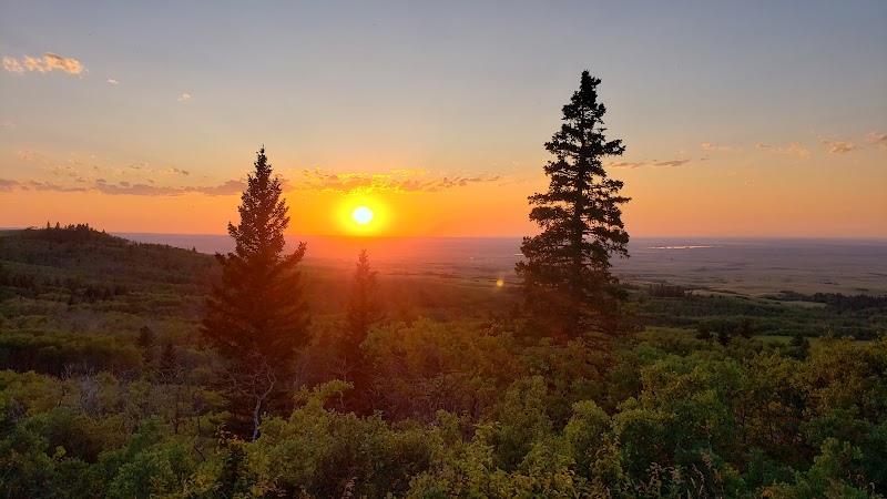
Reaching the summit, the landscape opens up in a wide breath—a panoramic sweep of rolling prairie and forested hills stretching beyond the horizon. The wind here doesn’t just blow; it urges you onward, pushing your eyes across distant ridges and valleys carved by time. From this vantage point, the vast expanse of the Cypress Hills asserts its independence: no ordinary hills, but a plateau rising defiantly above the surrounding plains.
Navigating this route demands respect. The trail’s uneven ground requires balanced steps and steady pacing, while the variable weather can shift quickly, turning warmth to wind chill. Water and snacks are non-negotiable; the body must keep pace with the mountain’s challenge. Early morning or late afternoon hikes offer cooler temperatures and softer light, but they also call for readiness against sudden fog.
Practical preparation is key. Wear layered clothing suited for Saskatchewan’s variable climate, take a reliable map or GPS, and carry enough water—at least two liters per person. Footwear with good ankle support and traction will protect you over the rocky, sometimes loose soil. Along the route, several rest spots allow quiet moments to absorb the forest’s watchful calm before the final push to the summit.
This hike isn’t about conquering nature but engaging with a landscape that is fiercely alive and refuses to be anything but genuine. The Head of the Mountain Trail offers an adventure braced by pragmatic care and rewarded with a sweeping view that commands attention and respect—a perfect mix of challenge and beauty worth the effort.
Nearby Trips
All Adventures
Boat Charters
Water Activities
Adventures near Maple Creek
Discover the unique and memorable adventures that make Maple Creek special.
Frequently Asked Questions
How difficult is the Head of the Mountain Trail?
The trail is rated moderate, with a consistent 180-meter elevation gain over 6.5 kilometers. It demands good fitness and surefootedness due to rocky and uneven terrain.
Is the trail suitable for children or beginners?
While doable for older children accustomed to hiking, the terrain can be challenging for beginners due to elevation and root-covered paths. Preparation and pacing are essential.
Are pets allowed on the trail?
Yes, dogs are allowed but must be kept on leash to protect local wildlife and ensure safety on narrow trail sections.
What wildlife might I see along the trail?
Keep an eye out for mule deer, red foxes, and an array of bird species including the northern flicker and sharp-shinned hawk.
Is there cell phone coverage on the trail?
Cell service can be spotty or nonexistent in parts of Cypress Hills. It’s best not to rely on mobile phones for navigation or emergency contact.
Can I camp near the trailhead?
Cypress Hills offers designated campgrounds with amenities a short distance from the trailhead, providing convenient spots to rest before or after your hike.
Recommended Gear
Hiking Boots
Strong ankle support and solid grip will keep your footing steady on rocky and possibly slippery surfaces.
Layered Clothing
Allows you to adjust to rapidly changing temperatures and weather conditions throughout the hike.
Hydration Pack or Water Bottles
Critical for maintaining energy and preventing dehydration, especially with the trail’s steady climb and exposed summit.
GPS or Trail Map
While the trail is well marked, having a navigation tool ensures you stay on course and can track your progress.
Local Insights
Hidden Gems
- "Look for the small rocky outcrop halfway up with a quiet spot perfect for a reflective pause away from the summit crowds."
- "The lesser-traveled Prairie Viewpoint, accessible from a side path near the trail’s end, offers unique southeastern views."
Wildlife
- "The rare swift fox occasionally crosses these hills, though sightings require patience and quiet movement."
- "Birdwatchers can spot the elusive boreal chickadee among the spruce stands."
History
"Cypress Hills was a significant meeting point for Indigenous peoples and early fur traders; the hills stand as a natural crossroads with cultural ties reflected in local heritage exhibits at nearby visitor centers."